Today the mountain climb included more than simply summiting Mt Myoujingatake. This climb involved route finding that included decisions for which trains and busses to board, which country road to hike to get to the trailhead, then which trail route to take by navigating from a Japanese topo map written in Kanji, and how to get home.
I climbed up one side of the mountain, summited, then hiked down the other side looking for a ride home. I had spotted a small community from the mountain top so I headed down the mountain in that direction. Well ... the town didn't have a train station, but even with my pitifully small Japanese vocabulary, I was able to obtain some guidance from kindly locals and, a bus ride later, and with some small town route finding, I was able to locate a station and get home (whew!).
Oh, I met a crew of Japanese hikers and had a nice chat on the summit. I am finding that with Japanese hikers and small town locals, you really don't need to speak the same language to communicate on a personal level.
Anyway, I took a few pictures on the mountain as you will see below.
Click picture for a LARGER IMAGE.
Trail up to Summit

Mt Myoujingatake
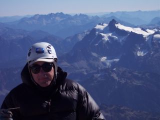
 Paul on Summit of Mt Myoujingatake
 View From Mountain Summit
 View of Mt fuji From Summit
0 comments:
Post a Comment